Fluctuations in Great Lakes levels
Learn about long-term, seasonal and short-period water level fluctuations in the Great Lakes, and how they’re affected by wind-induced waves.
On this page
- Factors affecting lake water levels
- Long-term fluctuations
- Seasonal fluctuations
- Short-period fluctuations
- Wind-induced waves
Factors affecting lake water levels
Fluctuations in water levels in non-tidal areas are the result of natural factors and human activities. These factors operate on a time-scale that varies from hours to years.
The water levels of the Great Lakes depend on the:
- storage capacity of the lake
- outflow characteristics of the outlet channels
- amount of water supply received by each lake
- operating procedures of the regulatory structures
The primary natural factors affecting lake levels include:
- precipitation on the lakes
- inflow from upstream lakes
- run-off from the drainage basin
- outflow to the downstream lakes
- evaporation from the lake surface
Man-made factors include:
- regulation of outflows
- consumption of water
- dredging of outlet channels
- diversions into or out of the basin
Long-term fluctuations
Long-term (multi-year) water level fluctuations result from persistent high or low net basin supplies. For some lakes, this results in:
- extremely high levels, such as in 1952, 1973 and 1985 to 1986
- extremely low levels such as in 1926, the mid-1930s and mid-1960s
More than a century of records in the Great Lakes basin indicate no regular, predictable cycle. Over a number of years:
- only some of the lakes may be affected
- there can be wide and erratic:
- intervals between periods of high and low levels
- length of such periods
The maximum recorded range of monthly water levels looks at the extreme high to the extreme low. For Lake Superior, this has varied from 1.2 metres to over 1.8 metres for the other lakes.
The ranges of levels on lakes Michigan-Huron, Erie and Ontario reflect the fluctuation:
- in supplies from their own basins
- of the inflow from upstream lakes
The following images show plots of average annual water levels recorded on each of the Great Lakes for the period of 1918 to 2018.
Seasonal fluctuations
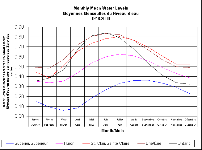
Seasonal (1-year) fluctuations of the Great Lakes water levels reflect the annual hydrologic cycle. This is characterized by net basin supplies that are:
- lower during most of the year
- higher during the spring and early summer
The maximum lake level usually occurs in:
- June on lakes Ontario and Erie
- July on lakes Michigan-Huron
- August on Lake Superior
The minimum lake level usually occurs in:
- December on Lake Ontario
- February on lakes Erie and Michigan-Huron
- March on Lake Superior
Based on the monthly average water levels, the magnitudes of seasonal fluctuations are quite small, averaging about:
- 0.4 metres on lakes Superior, Michigan and Huron
- 0.5 metres on Lake Erie
- 0.6 metres on Lake Ontario
However, in any single season, it has varied from:
- less than 0.2 metres to more than 0.6 metres on the upper lakes
- less than 0.3 metres to more than 0.8 metres on Lake Erie
- 0.22 metres to 1.10 metres on Lake Ontario
The following image shows a plot of the average monthly mean water level for each of the Great Lakes for the period of 1918 to 2000.
Short-period fluctuations
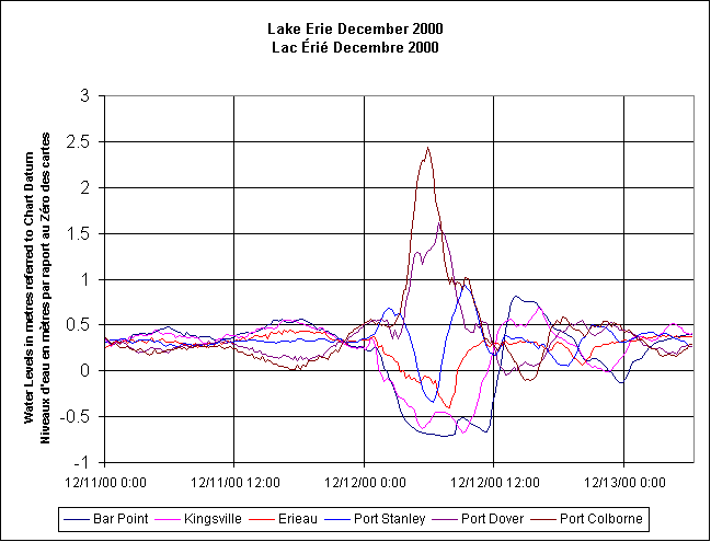
Short-period water level fluctuations can last from less than an hour to several days. They’re caused by meteorological conditions. The effect of wind and differences in barometric pressure over the lake surface create temporary imbalances in the water level at various locations.
Storm surges are largest at the ends of an elongated basin, particularly when the long axis of the basin is aligned with the wind. In deep lakes such as Lake Ontario, the surge of water level rarely exceeds 0.5 metres. In shallow Lake Erie, water-level differences (from one end of the lake to the other) of more than 5 metres have been observed. Although the range of fluctuations may be large, there are only minor changes in the volume of water in the lake.
A seiche is the free oscillation of water in a closed or semi-closed basin. They’re frequently observed in:
- bays
- lakes
- harbours
- almost any distinct basin of moderate size
The following plot shows hourly water level for 3 days, from December 11 to 13, 2000, at 6 gauging stations on the north shore of Lake Erie. It shows the water level fluctuations caused by storms.
Locations for the gauging stations include:
- Bar Point at the mouth of the Detroit River
- Kingsville in the western basin
- Erieau and Port Stanley in the central basin
- Port Dover and Port Colborne in the eastern basin
Wind-induced waves
Superimposed on all 3 categories of water-level fluctuations are wind-induced waves.
Surface waves can be a hazard to navigation and are also the main cause of shore erosion. They start small, but as they travel more or less downwind they grow in height, become longer and move faster. Although the Great Lakes are large, the fetches they present to the winds ensure that the waves are under-developed (except in light winds) and tend to be steeper.
Characteristics of waves on the Great Lakes include:
- faster moving under-developed waves, compared to fully-developed waves of the same length
- the longest and much steeper waves in an undeveloped sea , compared to those in fully-developed seas
- lack of ‘swell’ (long waves propagating from distant storms) because of the closed boundaries
- diverging large waves moving from the wind direction towards the long-fetch direction when the fetch varies substantially about the wind direction


